When you live only 35 miles from a Communist country, the most heavily guarded border in the world, and both countries on either side of the border are technically still at war with each other you can't help but be curious and get the urge to explore....North Korea, here we come!
I have been wanting to cross the Demilitarized Zone (DMZ) off of my "To Do" list for quite some time and very early on Saturday morning we did. It's interesting because I've found that many people will live here for a while and only get up to the 38th parallel after a couple of years of being here. Why wait!? It's only an hour away! An hour away from a place that no one in the world knows really anything about, and since they're technically still at war there's no fantastic time to go but since there aren't any real battles currently waging, why not go as soon as possible!? And there are daily tours! Thanks to the millions of other curious residents and tourists such as myself, tours to the DMZ and all that it entails are conducted by both the USO and private companies. I had heard that the USO tours were the best, as they are the only ones who are allowed to take you into the JSA (Joint Security Area...more on that later) where you actually get to step inside North Korea. Sign. Us. Up!
The tours get sold out weeks in advance but we got lucky with only having two wait two weeks. The price was $80.00 per person (only payable in actual US Dollars and in person....so inconvenient) It's $96.00 if you pay by credit card....and while we do have some Dollars lying around the house from previous trips home, we couldn't come up with $80, so we paid the premium. It was COMPLETELY worth it. After all, it's tough to put a price on getting the opportunity to peer into secret, communist lands....and actually step foot on their soil.
This was our tour itinerary:
09:00 : Departure from Camp Kim USO
10:00 : DMZ Theater, The Third Infiltration Tunnel, Dora Observatory and Dorasan Station
12:00 : Lunch at the Korean Restaurant
13:00 : After an informative video at Camp Bonifas and a presentation by a member of the U.S. military 20 Minute Briefing at JSA Visitor Center, Tour to the JSA area (Freedom house, Conference room, Bridge of no return and point of Ax murder)
15:30 : Depart back to Camp Kim USO
14:30 : Arrive at Camp Kim USO
Camp Kim USO
Located adjacent to Yongsan Garrison in Seoul, Camp Kim is home to a USO facility, an Army and Air Force Exchange Service (AAFES) distribution and storage facility, an AAFES vehicle repair facility, and the Yongsan Garrison office for vehicle registration and decals. The USO facility consists of a canteen, tour and ticket office, the Virtues Development Program, the Good Neighbor Program and a big screen television lounge. The USO also offers numerous programs designed to promote cross-cultural understanding through English education for Korean school-age children. The place looks like an army facility, non-descript and rather dull, but the t.v. lounge where our tour group was meeting had much familiarity: autographed posters from country music stars and groups like the Dallas Cowboy Cheerleaders and even flyers for college programs....in Texas.
The USO at Camp Kim.
Clearly the U.S. spared no expense on this facility.
Waiting for departure.
The Lone Star presence is everywhere!
Load 'em up! Off to the DMZ!
The History of the DMZ
The Demilitarized Zone (DMZ) is a strip of land running across the Korean Peninsula that serves as a buffer zone between North and South Korea, running along the 38th parallel north. The DMZ cuts the Korean Peninsula roughly in half, crossing the 38th parallel on an angle, with the west end of the DMZ lying south of the parallel and the east end lying north of it. It is 160 miles long,
approximately 2.5 miles wide and is the most heavily militarized border in the world.
The 38th parallel north was the original boundary between the United States and Soviet brief administration areas of Korea at the end of World War II. Upon the creation of the Democratic People's Republic of Korea (DPRK, informally North Korea) and the Republic of Korea (ROK, informally South Korea) in 1948, it became a de facto international border and one of the most tense fronts in the Cold War. Both the North and the South remained heavily dependent on their sponsor states from 1948 to the outbreak of the Korean War.
The conflict, which claimed over three million lives and divided the Korean Peninsula along ideological lines, commenced on June 25, 1950, with a full-front North Korean invasion across the 38th parallel, and ended in 1953 after international intervention pushed the front of the war back to near the 38th parallel. In the Armistice Agreement of July 27, 1953, the DMZ was created as each side agreed to move their troops back 2,200 yards from the front line, creating a buffer zone 2.5 miles wide. The Military Demarcation Line (MDL) goes down the center of the DMZ and indicates exactly where the front was when the agreement was signed. Since the Armistice was signed, it has been monitored by members of the Neutral Nations Supervisory Commission (NNSC). Since 1953, members of the Swiss and Swedish Armed Forces have been members of the NNSC stationed near the DMZ.
Owing to this theoretical stalemate, and genuine hostility between the North and the South, close to 1 million troops are still stationed along both sides of the line, each side guarding against potential aggression from the other side. The armistice agreement explains exactly how many military personnel and what kind of weapons are allowed in the DMZ. Soldiers from both sides may patrol inside the DMZ, but they may not cross the MDL (Military Demarcation Line). Sporadic outbreaks of violence due to North Korean hostilities has killed over 500 South Korean soldiers and 50 U.S. soldiers along the DMZ between 1953 and 1999.
Interestingly enough, civilian life does exist within the DMZ. Tae Sung Dong in the South and Kijong-dong in the North were the only villages allowed by the armistice committee to remain within the boundaries of the DMZ. Residents of Tae Sung Dong are governed and protected by the United Nations Command and are generally required to spend at least 240 nights per year in the village to maintain their residency. In 2008, the village had a population of 218 people, but the population is decreasing as many residents are more interested in leaving to work in Seoul than to continue farming the land. The villagers of Tae Sung Dong are direct descendants of people who owned the land before the 1950–53 Korean War and work as rice farmers. Women are allowed to marry into the village but since all South Korean men are required to serve in the military, men are not. Despite the serene isolation of the village, it is under constant military protection as there have been incidents of kidnappings by the North as the villagers work in the fields. There are also strict rules that they must abide by like being inside their homes by sundown and all lights out by 10:00 p.m. The Northern village of Kijon-dong also has a more informal and endearing name: Propoganda Village. More on that later but it's safe to say that there's no rice farming going on there.
Although the Korean DMZ has been a deadly place for humans, making habitation nearly impossible, this natural isolation along the DMZ has created an involuntary nature preserve which is now recognized as one of the most well-preserved areas of temperate habitat in the world. Several endangered animal and plant species now exist here including the extremely rare Red-crowned Crane (a staple of Asian art), the White-naped Crane as well as, potentially, the extremely rare Korean Tiger, Amur leopard and Asiatic black bear. Ecologists have identified some 2,900 plant species, 70 types of mammals and 320 kinds of birds within the narrow buffer zone. The DMZ owes its varied biodiversity to its geography which crosses mountains, prairies, swamps, lakes and tidal marshes. Environmentalists hope that the DMZ will be conserved as a wildlife refuge, with a well-developed set of objective and management plans for the future.

Thanks to the USO Tour, we not only got to go to the DMZ border
but were able to go to the MDL (Military Demarcation Line)
and the white dot labeled Panmunjom JSA (Joint Security Area).
Image courtesy of USO website.
Almost there! It's completely deserted and definitely eerie.
Tour Stop #1
The Third Infiltration Tunnel
The first stop on the tour was to the DMZ Visitors Center and site of the 3rd Infiltration Tunnel. We first viewed a short movie on the DMZ that took us through a very quick history but focused primarily on the necessary preservation of the ecosystem that exists there. After the video, we proceeded through a small museum of the DMZ with information on important events throughout it's history and some relics of war. We then proceeded outside to enter the tunnel....only after passing by the first of many gift shops.
The 3rd Infiltration Tunnel was discovered on October 17, 1978. Only 27 miles from Seoul, the tunnel was discovered based on information provided by a defector. It is 1.1 miles long, 6.6 ft high and 6.6 ft wide. It runs through bedrock at a depth of about 240 ft below ground. It was apparently designed for a surprise attack on Seoul from North Korea and can easily accommodate 30,000 men per hour along with light weaponry. Upon discovery of the third tunnel, the United Nations Command accused North Korea of threatening the 1953 armistice agreement signed at the end of the Korean War. Initially, North Korea denied building the tunnel. However, drill marks for dynamite were found in the walls pointing towards South Korea and the tunnel is inclined so that water drains back towards the northern side of the DMZ. North Korea then officially declared it part of a coal mine and painted the walls black to help confirm this statement. However, there is no geological likelihood of coal being in the area since the walls of the tunnel where tourists are taken are observably granite, a stone of indigenous origin, whereas coal would be found in stone of sedimentary origin. A total of four tunnels have been discovered so far, but there are believed to be up to twenty more. South Korean and U.S. soldiers regularly drill in the DMZ in hopes of finding them.

Out in front of the DMZ visitors center.
I promise the tour got much more serious and scary
as we got further away from the pink and purple sign...
...and toy soldiers.
Outside the entrance to the tunnel.
After walking down a long pathway, we eventually hit the tunnel. We had
to wear hard hats which actually came in handy because most of the way
through we were bent over, trying to avoid hitting our head. Our tour guide
stayed on the surface. It was much different than touring a cavern. This was
more like touring an old mine shaft, little safer though....I would hope.
This is the pathway way that leads you down to the actual tunnel.
It was pretty steep and much easier going down than up.
Most people were scattered along the sides
on the way back up, catching their breaths.
Then we stopped at the gift shop that had everything...
... from pieces of boxed barbed wire, hats, golf balls.....
....rice....
....to North Korean liquor and wine.
I'm not quite sure how this is even possible and it's probably illegal
but we bought some along with everyone else.
It's somewhat fantastic that the capitalist side of the peninsula makes a profit
off of products from the communist side.
Tour Stop #2
Dora Observatory
After being allowed time to peruse the gift shop, we loaded back on the bus and headed to the Dora Observatory to get our first glimpse into North Korea. Situated on top of Dorasan (Mount Dora), the observatory looks across the DMZ into North Korea. Before arriving we were given strict instructions about taking photographs; photographs were allowed but only to be taken behind the yellow line. If you took pictures beyond the yellow line your camera would be confiscated by a South Korean soldier on duty. We got pretty lucky as the visibility started to clear up around this time so although the photos don't really show anything we were able to faintly see some North Korean terrain from observatory.
This is the closest the non-USO tours get to seeing North Korea. The highlight of our tour had yet to come, after lunch, when we got to get even closer to the Communists, so we're okay with the fact that these pictures didn't really turn out so great.
Dora Observatory
Everyone behind the yellow line doing their best to capture an image of North Korea.
For 500 won (about 50 cents) you can look through the binoculars to get a closer view.
First glimpse of the so-called "hermit kingdom".
Tour Stop #3
Dorasan Station
After peering into foreign lands, we boarded the bus to head over to Dorasan Station. Dorasan Station is a railroad station which once connected North and South Korea and has now been restored and was opened in 2002 after a June 2000 joint declaration between North and South Korea to connect the Gyeongui Railroad line. It was closed in 2008 though and now sits empty due to a disagreement between the two countries. Dorasan Station has become well known as a place of inspiration for the reunification of the Korean peninsula and world peace and many peace events have been held here. A sign out front also proclaims that when the Trans Korean Railway is able to connect to the Trans Siberian Railway and the Trans Chinese Railway, South Korea promises to emerge as a distribution hub in Northeast Asia, making Dorasan Station the gateway toward Eurasia in the near future.
The station is now only open to tourists but for $1.00 you can purchase a ticket to go out onto the platform and take pictures with the signs indicating which direction is Seoul and which direction is Pyeongyang, the North Korean capital. They even let you climb down on the tracks and walk around. It's an eerily quiet place, but hope still remains that one day the the trains will run again, as everyone speaks in terms of "when" not "if".
The shape of the stations was designed to resemble two clasped hands,
symbolizing the hope that reunification will one day happen.
"Kristina", our tour guide, explaining the potential of the railway
if it were to ever extend north and how it would
connect Korea to the rest of the world.
Looks just like any normal train Station in Seoul...
...except this one goes to the North Korean capital.
The military police were very friendly and I'm sure love that this is a tourist spot...
makes the day a little more exciting I would imagine.
Completely deserted, but ready and waiting to re-unify everyone.
Advertisement out on the platform.
Good ol' W and former South Korean President Kim Dae Jung (1925-2009) at Dorasan.
President from 1998-2003, Kim Dae Jung won the Nobel Peach Price in 2000
and was often referred to as the "Nelson Mandela of Asia"
for his long-standing opposition to authoritarian rule.
Wasn't W the one to coin the phrase "Axis of Evil"?
Which way should I go!? Such a difficult decision, they're both so close!
Looking north, the road to the future.
Maybe she will one day take the train to Pyeongyang!
Lunch Time!
Before heading to the highlight (and scariest part) of the tour we stopped for lunch at a Korean restaurant within the DMZ. The price was not included in the tour price but only set us back $10.00 each for a choice between two yummy Korean staples that even if you don't like Korean food, you'd eat: bibimbap or bulgogi. Before arriving at the restaurant, our tour guide called ahead to the restaurant to ask if they were going to have any North Korean beer available. They confirmed and indeed everyone on the tour bus was quite excited. It's actually illegal, so it's apparently not always available, and I'm not sure how it would actually get smuggled in anyway, but we got lucky....and it tasted as expected, light like the South Korean Cass brand we drink with BBQ but less tasty so it was more like Budweiser. We did bring home the bottle as a souvenir because you never know, it might be worth something when the two sides makes peace and re-unify.
South Korean food with North Korean beer.
Tour Stop #4
The JSA (Joint Security Area)
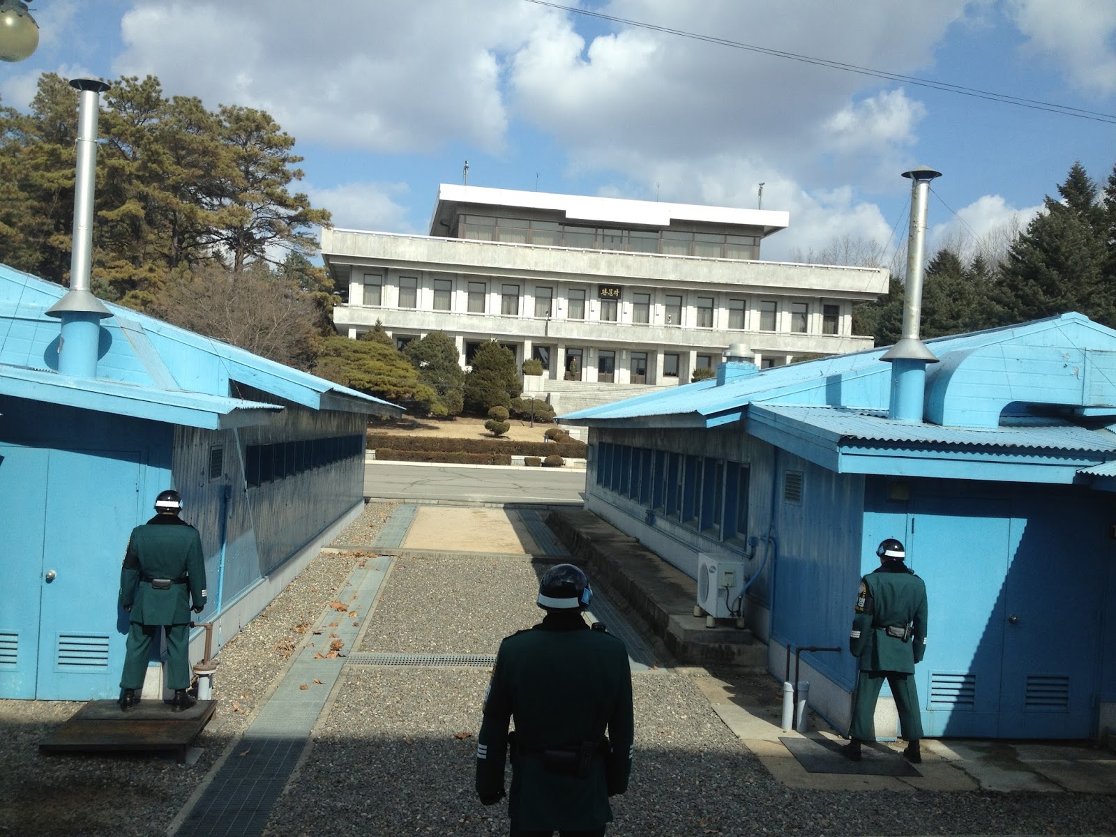
After lunch we boarded the bus to one of the most secure and heavily guarded areas in the world and most tense part of the entire DMZ area; the Joint Security Area (JSA). Here we would sign a waiver, trade our USO tour guide for U.S. Military Police and get much to close to Communism.
Inside the DMZ, near the western coast of the peninsula, Panmunjeom is the home of the Joint Security Area (JSA). The JSA is the location where all negotiations since 1953 have been held, including statements of Korean solidarity, which have generally amounted to little except a slight decline of tensions. There are several buildings including conference rooms and guard posts on both the north and the south side of the Military Demarcation Line (MDL), and a few are built right on top of it. The MDL goes through the conference rooms and down the middle of the conference tables where the North Koreans and the United Nations Command (primarily South Koreans and Americans) meet face to face. Facing the UN buildings is North Korea's Panmungak (English:
Panmun Hall) and South Korea's Freedom House. In 1994, North Korea enlarged Panmungak by adding a third floor. In 1998, South Korea built a new Freedom House for its Red Cross staff and to possibly host reunions of families separated by the Korean War. The two sides continuously enjoy outdoing each other building achievements.
Though generally calm, the JSA has been the scene of many incidents over the years between the two Koreas. The most disturbing thing to happen is probably the Axe Murder Incident in August 1976 which involved the attempted innocent (and legal) trimming of a poplar tree (located on the South Korean side) by U.S. and South Korean soldiers that was blocking the view from one guard post to another. North Korean soldiers quickly descended upon the group and after arguing the North Koreans axed CPT Arthur Bonifas and 1LT Mark Barrett to death. As an immediate result of the the Axe Murders, everything went into DEFCON 2 (total war) state. Following that, Operation Paul Bunyan occurred which was the final and successful attempt to remove the poplar tree. Beforehand, the soldiers of both sides were permitted to go back and forth across the MDL inside of the JSA, a privilege since revoked as a result of this incident. It is also said that Operation Paul Bunyun was the most expensive tree removal in history as every part of the military - fighter jets, air craft carriers, destroyers, not to mention thousands of troops - were sent out and on alert as the tree was removed.
Another incident occurred on November 23, 1984, when a Soviet tourist, who was part of an official trip to the JSA (hosted by the North), ran across the MDL shouting that he wanted to defect. North Korean troops immediately chased after him opening fire. Border guards on the South Korean side returned fire eventually surrounding the North Koreans as they pursued the Russian national. One South Korean and three North Korean soldiers were killed in the action but the defector was safe and not returned to North Korea.
Despite these incidents that were communicated to us by our U.S. MP guide, during an excellent presentation and briefing, upon arrival at Camp Bonifas (named for one of the victims of the axe murders), much to our relief there have been no incidents involving tour groups (except the defector on the Northern tour). After the briefing we signed our life away on a form handed out to everyone, basically saying we were about to enter a "hostile area and the possibility of injury or death could be the result of enemy action....and the the United Nations, the United States of America and the Republic of South Korea can not guarantee your safety or be held accountable in the event of a hostile enemy act." I signed without even reading it.
After signing the disclaimer, putting on yet another clip-on tag and being given strict instructions as to when and when not to take pictures we boarded a military bus and went to face the enemy.
As we arrived at Camp Bonifas inside the JSA, we were stopped at the
checkpoint so that two U.S. MP's could check everyone's passports on the bus.
Receiving our briefing, history of the JSA, signing our life away....
...you know, routine tour protocol.
I didn't actually read the whole thing, but RCP did.
We've made it to the Axis of Evil!
Facing Panmungak in North Korea.
The blue buildings are U.N. buildings and the one on the left is the conference room
where talks are held, the two soldiers in green are South Korean soldiers.
There was one North Korean soldier standing on the other side,
at the top of the stairs to the left....curious enough to pull out his
binoculars and stare at us halfway through the tour.
The atmosphere here was tense to say the least
as we were asked to stay in two single files rows,
not make sudden movements, gestures, loud noises or taunt the enemy in any way.
Our guide giving us some more interesting facts about the other side....
..such as there are North Korea guard posts just outside this picture
(that we were not allowed to take pictures of) that record
every single thing that happens on this side....
so we're definitely on a videotape in the archives of the North Korean military.
Our side also records the North Koreans and the videos often reveal lovely taunts
and hand gestures performed by the enemy that US soldiers find incredibly entertaining.
And we're in! Still on South Korean soil though, on this side of the conference room.
The conference table with the flag is where the talks are conducted and the booth with
the glass windows is where the translator for each side would sit. They now sit at the tables with
the meeting parties. The two South Korean soldiers are in the room for our protection.
There used to be only one on guard, but after an incident when a South Korean soldier
was almost pulled into North Korea as he was trying to close the door behind him, there are now two
for the sole purpose of one holding the other inside the building as they close the door when needed.
The soldiers now wear sunglasses due to past skirmishes
after North Korean soldiers accused the South of
making gestures and taunting them with their eyes.
I wonder what they're actually thinking as tourists file in an out of here?
And now, technically, we're in North Korea!
(But with a South Korean soldier, so not to worry).
These soldiers stand in a modified taekwondo, ready to fight position, all day long
and all are black belts in some sort of martial arts.
This is looking out the window at the neighboring blue buildings. The soldier stands with half his
body covered by the building in case something were to break out,
he has a better chance of being protected.
Me in North Korea!
You can stand at least 6 inches away from the soldiers.
If you get any closer, they will stomp their heel once, signaling you to get back.
If you fail to move, they will touch you and gently remove you.
One last look before heading out.
Keep an eye out for us!
After crossing over into North Korea for a brief moment,
we boarded the bus and continued our military guided tour
to a few other less tense but important parts of the JSA.
The white markers indicate the actual Military Demarcation Line.
And here we are in North Korea's back yard.
Communism lives in a beautiful place, doesn't it?
The small white structure in the distance is a North Korean guard tower that records everything.
This point is often recorded as the coldest spot on the entire Korean peninsula,
since those cold Siberian winds have not much to stop them.
We were still not allowed to point or make gestures of any kind.
Only our MP guide was allowed, because North Korea knows they're giving a tour.
Another interesting fact is that there are telephone booths located throughout the entire length
of the DMZ border. The booths are there for any defectors from the North who actually do
make it across. They can pick up the phone and call and U.S. and South Korean military will
come find them and take them to safety. This happens quite often further away from the JSA.
It was very peaceful and serene...
and there's no cell phone service anywhere near this area,
as the North Koreans have an enormous tower
that jams all radio contact in and out of North Korea.
Welcome to Kijong-dong, N. Korea, better known as Propoganda Village!
The Story of Propoganda Village and it's Flagpole
Both North and South Korea maintain peace villages in sight of each other's sides of the DMZ. I wrote of the South's village, Daeseong-dong, earlier who farm the rice fields. In the North, Kijong-dong features a number of brightly painted, poured-concrete multi-story buildings and apartments with electric lighting. These features represented an unheard of level of luxury for rural Koreans, north or south, in the 1950s. The town was oriented so that the bright blue roofs and white sides of the buildings would be the most distinguishing features when viewed from the border. However, scrutiny with modern telescopic lenses reveals that the buildings are mere concrete shells lacking window glass or even interior rooms, with the building lights turned on and off at set times and the empty sidewalks swept by a skeleton crew of caretakers in an effort to preserve the illusion of activity. Until 2004, massive loudspeakers mounted on several of the buildings continuously delivered propaganda broadcasts directed towards the south as well as propaganda radio broadcasts across the border heard by all U.S. and S. Korean military personnel. In the 1980s, the South Korean government built a 323 ft tall flagpole with a 287 lb South Korean flag in Daeseong-dong. The North Korean government responded by building what was then the tallest flagpole in the world at 525 ft with a 595 lb North Korean flag in Propaganda Village. This has been referred to as the "flagpole war."

After taking in the North Korean landscape and fake village, we boarded the bus
to head back to Camp Bonifas to conclude the tour, but only after passing two sights:
the sight of The Axe Murders and Operation Paul Bunyan mentioned earlier (the round
concrete circle is where the poplar tree that caused the incident used to stand)....
...and The Bridge of No Return....
where POW's were exchanged by both sides at the end of the Korean War.
They were given a choice as to which side they'd like to stay on,
with the understanding that if they crossed the bridge to the North
they would never be allowed to come back.

Traveling along the DMZ back to Seoul, in all it's serenity, barbed wire, and security cameras.
And That Concludes the Tour.....
Visiting the DMZ in it's entirety has been probably the most exciting site we've seen while living here. I have not really visited too many, if any, real battlefields anywhere and to step foot into neutral territory of two nations technically still at war was thrilling! Even though I'm not Korean and didn't experience the tragic division of history and families first-hand and don't even really remember learning one bit about the Korean War in American History, the entire experience was incredibly moving, thought-provoking, and definitely has made me more sensitive to the history and events of the Korean peninsula that have shaped South Korea into the place it is today. To learn about their outlook and hope for the future was a very humbling experience.
And yet all I have to show for it, besides the pictures, is this coffee mug.
("In Front of Them All" is the motto at Camp Bonifas.)